Topo Maps app for iPhone and iPad
4.6 (
7296 ratings )
Travel
Navigation
Developer:
Mappendix Limited
7.99 USD
Current version:
1.19, last update: 9 months ago
First release : 27 Mar 2009
App size: 112.24 Mb
* View over 70,000 Natural Resources Canada 1:50,000 and USGS 1:24,000 topographical maps on your iPhone or iPod touch. * Ideal for hiking and other backcountry activities. * Map downloads are FREE! * More than 16 million maps downloaded so far!
- iPad owners, please see the app "Topo Maps for iPad".
* Users write:
" Ive bought all the topo map apps and I like this the best "
" Scans are gorgeous ... the interface is exceptionally clean "
" Downloading maps is easy and fast ... Map displays beautifully and zooms flawlessly "
* Includes Canada (at 1:50,000), the contiguous US (at 1:24,000), Alaska (at 1:24,000 and 1:63,360), Hawaii, Puerto Rico and the U.S. Virgin Islands.
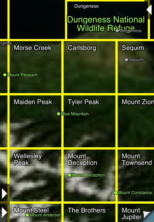
* Locate the maps you need on the satellite view. To install a map, touch for about half a second. Touch again to view it.
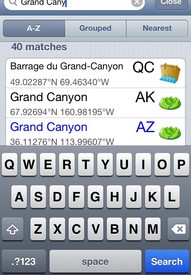
* Search by name for over a million towns, peaks, lakes, parks and other features.
* No network connection is needed once the maps have been installed.
* Mark waypoints, and import and export waypoint files in GPX, KML and CSV formats.
* Touch the "current location" button to see where you are, and the compass button to align the map with the ground.
* See coordinates in NAD27 or WGS84 degrees, degrees minutes and seconds, UTM, or MGRS formats.
* Measure distances (miles, feet and km) and bearings (true and magnetic).
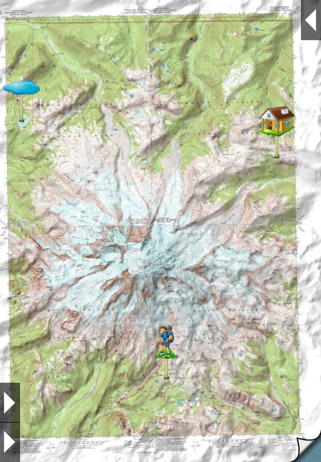
The Maps: This app uses high-quality scans of the traditional USGS and NRCan topographic maps which have been the definitive resource for hikers and other backcountry users for many years. You can make the terrain stand out with hill shading, using simulated sunlight from the direction of your choice. In the U.S., this app does not use the new "US Topo" maps because they do not show hiking trails and lack other details: please see the web site for more details.
Downloading: US maps are around 8 MB in size and download in a few seconds on a typical home broadband connection. Canadian maps are larger. Both cellular data and WiFi can be used, though WiFi is likely to be more reliable in most cases.
- Do please visit https://topomapsapp.com/ for complete instructions, so that you dont miss any features.
We have many ideas for additional features to add to future versions of this app; if you have ideas or other questions or comments, contact details can be found on the website, https://topomapsapp.com/. The website also has more screenshots and other information.
Pros and cons of Topo Maps app for iPhone and iPad
Topo Maps app good for
This is a well thought-out app with intuitive interface and lots of options. Fills a much-needed niche of on-board Topo Maps - which are downloaded for free from NRCan (for Canada) via a simple tile interface or via Search, which seems to be pretty comprehensive. Touch-and-hold controls are a nice touch (not intuitive - but help manual is very complete).
Now - with a basic topo viewer, the next step is to provide an ability to save waypoints, record a trek (start, pause, save), share a trek (out to GoogleMaps/Earth via kml), view elevation profile of a trek, measure distances, etc etc.. (this is where the 5th star would come from).
Great start with new features to follow hopefully! Defintely worth the modest price - Check this app out - Drew
Now I can find my way when Im out of cell range :) This app works great! I hope they add the option to add waypoints and tracks.
I could see myself using this for work purposes now. It would be nice to have the option to E-Mail the link of the topo map to view from desktop. I would also like to see the blue dot feature to track your movement that is standard in the IPhone Google map app. This would than be ideal for hiking if cell signal is not available. I think this app has good potential.
-----------------------------
Update:
The more I use this the more impressed I am with the features. I really like the elevation and coordinate feature. I am surprised how accurate this is as you move around the map. I also like that you can change the units and coordinate system just by clicking on it. It would be nice to have the ability to copy the coordinate. How about giving us 3d renderings of the maps in future updates. This would blow our socks off.
Thanks for the app.
Best value for money of any iPhone app I have ever tried! Outstanding.
I have been a map junkie all my life and now I have a huge collection of maps from the BC Coasts mountains with me at all times!
Awesome application, a must have for any backwoods buff. However, maps are not up to date for Canada - for the areas Ive downloaded already. There are more recent paper editions.
UPDATE: obtain and add the Adventure Maps by chrismar and ill gladly pay 400% more than current price. This just needs trail markings.
Some bad moments
horrible application the map are not up to date and are simply paper maps. YOU HEARD ME! No sattalite or hybrid!
No CaNaDa MAPS!!!
Good if free but its not. Waste of money.
Good idea to have Topo Maps handy in the palm of your hand. However the maps are so outdated they are almost useless around urban area. I could onLy get coordinates in lat and long no utm. They mean well but have a lot of improvement to make.
Maps are way out of date . Were talking at least 30 years. No joke!
Lots of room for improvment. Now if they could acquire "BackWoods Canada" maps then wed see the thousands of miles of logging roads that are out there. Nice for having some kind of map handy, but my Garmin GPS blows this away and I loaded my up-to-date topoCanada maps in it also. This app is "OK" just for play but I dont play around in the bush when your life may depends on it.
I hope they actually begin to get serious with this app. Theres a lot of possibilities to take advantage of in the future of maps and GPS. So far this app looks like its been quickly pieced together for a quick buck.
Now lets get on with some serious updates. We only got .99 worth of our $7.99 investment so far. Time will tell.
On my Bubble scale I say 3 bubbles out of ten.
You are better of with google earth and mapquest. Really....thats all this program is.
Canadian maps are horrible. Nothing compare to the maps on the government website.
Save your money!!
Looks great.... But do not waste your money like i did if u want MGRS. you can input the grids, but it only gives u long & lats. Useless to me. Waste of $7.99. Id give it 5 stars if it gave u MGRS...
Usually Topo Maps iOS app used & searched for
parks canada,
offline topo maps,
satellite maps,
topo maps,
topographic maps,
mappendix limited,
and other. So, download free Topo Maps .ipa to run this nice iOS application on iPhone and iPad.